
Tropical Storm Barry is the second named storm of the 2025 Atlantic hurricane season. It formed in the Bay of Campeche, off eastern Mexico, on June 29, 2025. As of now, Barry is not a hurricane; it remains a tropical storm. Still, it brings heavy rain, gusty winds, and flood risks. This storm may not reach high wind speeds, but flooding and mudslides can cause real damage.
In this guide, you will find a full breakdown of Barry’s:
- Formation and path
- Strength and weather effects
- Warnings and alerts
- Impact on Mexico and the U.S.
- Safety steps and tips
We use simple words, short sentences, and clear headings. This makes the information easier to read and understand. It also helps search engines like Google see it as helpful and user-friendly. Let’s explore Tropical Storm Barry.
What Is Tropical Storm Barry?
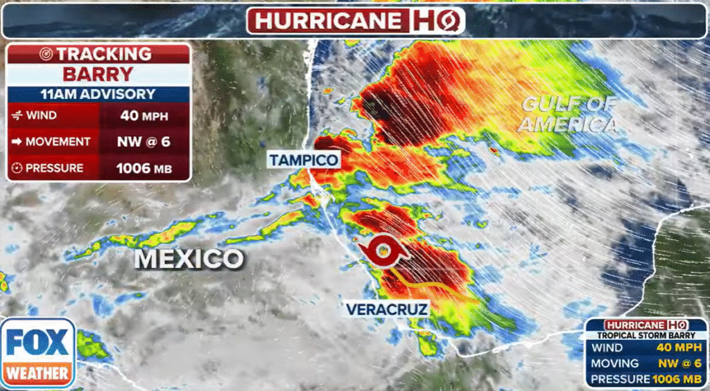
Tropical Storm Barry is a type of tropical cyclone. Such storms have warm centers and rotate around low-pressure areas. Barry started as a tropical depression before reaching tropical storm status with winds of 40 to 45 mph on June 29, 2025.
The National Hurricane Center (NHC) monitors storms like Barry. When a storm’s winds reach 39 mph, it receives a name. This one is Barry—the second of 2025, after Tropical Storm Andrea.
Barry is weaker than a hurricane. But it still brings challenges. Heavy rain, wind damage, and coastal surge can affect coastal areas. Gary also raises risks inland, especially in hilly regions prone to mudslides.
How Did Barry Form?
Barry formed over the Bay of Campeche, an area known for warm sea waters in the southern Gulf of Mexico. These warm waters are key for tropical storms to build strength.
- Initial cloud cluster: Satellite data showed a growing group of thunderstorms near Mexico’s coast.
- Developing low pressure: As it organized, the system showed signs of low-air pressure and wind rotation.
- Upgraded to depression: Storm warnings began as the system moved steadily northwest.
- Named “Barry”: When sustained winds passed 39 mph, the NHC named it Tropical Storm Barry.
Timing: Barry became a tropical depression earlier on June 29, 2025. Hours later, it hit the name threshold. The NOAA and NHC tracked Barry using satellites, radar, and weather balloons.
This pattern is normal for storms in this area. Warm Gulf waters often feed storms that threaten Mexico, the U.S., and beyond.
Barry’s Path and Forecast
Current Position and Movement
As of midday Sunday, June 29, 2025:
- Barry is ~50–90 miles east-southeast of Tuxpan, Veracruz, Mexico.
- It travels northwest at 6–12 mph.
- It is expected to make landfall Sunday night or early Monday, near Veracruz.
Track Forecast
The NHC projects Barry’s path:
- Sunday night: Landfall near Veracruz coast.
- Monday–Tuesday: Moves inland over mountains; weakens to a tropical depression.
- Tuesday night: Turning northeast across Tamaulipas and San Luis Potosí.
- Wednesday: Mostly dissipated; only rain bands remain.
The map shape (cone) shows a yield of possible paths. Most models focus on eastern Mexico. A slight shift affects which areas get the most rain.
Intensity Forecast
- Current wind strength: 40–45 mph.
- May strengthen slightly before landfall due to warm water.
- Will weaken fast once it hits the mountainous terrain.
- Forecast: peak just before landfall, degrade inland.
Warnings and Alerts
Mexico—Eastern Coast
- A Tropical Storm Warning is active from Boca de Catan to Tecolutla.
- This means tropical storm-force winds are expected within 36 hours.
Inland Alerts
States on watch include:
- Veracruz
- Tamaulipas
- San Luis Potosí
- Hidalgo
Public Advice
Authorities encourage residents to:
- Stay tuned to local TV, radio, and official updates.
- Charge phones and power banks.
- Fill water jugs and food supplies.
- Keep flashlights ready.
- Clear drains of debris.
- Move pets indoors and secure property.
- Have a safe room in case of flooding or wind damage.
Local governments have opened shelters in flood-prone zones. Evacuation plans exist in communities near rivers or hills.
Rainfall & Flood Risks
Rainfall Estimates
Barry is expected to bring:
- 3 to 6 inches of rain in most areas.
- Isolated totals up to 10 inches in mountain terrain.
- Risk high in Veracruz, Puebla, and northern Oaxaca.
Flood and Landslide Threat
Heavy rain in a short time can cause:
- Flash floods in low-lying towns.
- River overflow in mountain-fed rivers.
- Urban flooding where drainage is poor.
- Mudslides in steep inclines.
Known Risks by State
- Veracruz: Main path; flood and landslide risk high near Sierra Madre.
- Tamaulipas: Heavy rain possible as storm crosses inland.
- San Luis Potosí & Hidalgo: Rain from mountains may trigger landslides.
Emergency Response Teams
Responders include:
- Civil Protection (Protección Civil)
- Firefighters, National Guard
- Army units for rescue
- Medical services
They will:
- Help stranded residents
- Evacuate during danger
- Provide first aid
- Clear roads and debris
Residents should report rising waters or blockages to local lines.
Wind & Coastal Hazards
Wind Damage Risks
- Wind gusts may reach 50–55 mph near landfall.
- Possible effects: broken branches, light structural damage, power outages.
- Sea spray may damage coastal property.
Storm Surge Risk
- Low-level storm surge may add 1–3 feet of water to normal tide.
- High tide could push surge farther inland.
- Coastal road flooding can occur.
Sailing and Fishing Notices
Authorities have issued marine alerts:
- Small boat warnings are in place.
- Coastal travel by sea is not advised.
- Fishing boats have been told not to exercise.
Will Barry Affect the U.S.?
Direct Impact: Unlikely
Barry is forecast to weaken fast over Mexico. It is not a direct threat to the U.S.
Rain in Texas
However, outer rain bands may reach South Texas by mid-week. Houston, Corpus Christi, and Brownsville could see:
- Light to moderate rain
- Scattered thunderstorms
- No storm surge, small wind effects
This rain may help drought areas but also cause temporary flash floods. Texas residents should stay weather-aware.
Gulf Shipping
Moisture can cause rough seas between Texas and Mexico. Ships should monitor coastal forecasts.
History of the Name “Barry”
The name Barry has appeared in Atlantic storms since the early 1980s:
- 1983: A tropical storm that affected Florida.
- 2007: Made landfall in Florida; weakened quickly.
- 2013: Brought rain to Veracruz, no major damage.
- 2019: A Category 1 hurricane across Louisiana.
- 2025: The current Tropical Storm Barry.
Each storm had different strength and effects. This one is weaker but still risky.
How Storms Are Tracked
- Satellites: Track clouds and storm center.
- Doppler radar: Measures wind speed and rain near land.
- Weather balloons: Provide upper-air data.
- Ocean buoys: Measure wind and pressure at sea.
- Computer models: Predict path and strength.
Meteorologists use data to map the cone of uncertainty. This shows likely paths. Forecast centers update every few hours.
Updates include:
- Position
- Wind speed
- Pressure
- Rain forecasts
- Warnings
Safety Tips
Before the Storm
- Have a weather radio, flashlight, and spare batteries.
- Store one gallon of water per person per day.
- Keep non-perishable food for 3 days.
- Secure outdoor furniture and loose objects.
- Fill your car fuel tank.
- Know where shelters are and how to get there.
During the Storm
- Stay indoors and away from windows.
- Don’t walk or drive through floodwaters.
- Keep pets indoors and safe.
- Follow official orders.
After the Storm
- Wait for “all clear” before going out.
- Watch for fallen power lines.
- Avoid wading in floodwater.
- Use a flood pump if needed.
- Document damage with photos for insurance.
- Clean debris carefully.
Conclusion
Tropical Storm Barry is real and carries dangers, though it is not a hurricane. Expect wind, rain, floods, and mudslides in parts of eastern Mexico. Residents should stay prepared, watch alerts, and have supplies ready. Even if Barry is weaker, its water can cause serious harm—especially in mountains.
If you are in affected regions, please follow official advice. Keep your home safe, stay indoors, and be ready to move if officials tell you to. Careful planning now can save lives and reduce losses.
Frequently Asked Questions about Tropical Storm Barry
Tropical Storm Barry is a weather system that formed over the Gulf of Mexico in June 2025. It brings heavy rainfall, strong winds, and the risk of floods and landslides to parts of Mexico.
No, Barry is not expected to strengthen into a hurricane. It will likely weaken after landfall due to interaction with land and mountains.
The states of Veracruz, Tamaulipas, San Luis Potosí, and Hidalgo in Mexico are at the highest risk. These areas may experience flooding and landslides.
No major threat to the U.S. Barry may bring some rain to parts of South Texas, but there is no expected storm surge or strong wind impact.
Charge devices, store food and water, secure your home, and stay updated with official alerts. Avoid travel and follow local emergency guidelines.